Wednesday, August 31, 2011

Day 3 or Entry into Canada

We started our day with coffee, eggs & Beans and anticipation of entry into Canada.  We packed up camp fairly quickly and set out to locate the local dog park so we can tire out the dogs before the border.

We found the Thurston County Off-Leash Dog Area easily this time.  The county had turned their former landfill into a dog park, so it was huge.  The entrance had a huge bone made of brick at the entrance laid out to walk on into the main gate.  Too cute...


 Luther & BuddyJack played ball.  Over and over again.  Enough to tire them out and stay quiet as we started today's car ride.  Up I-5 until we reached Mt. Vernon were there was a detour.  This was our first for the trip, but certainly not our last.

It was recommended to take Route 9 for a few miles.  The road was winding and slow, but offered a very scenic route through the backroads of WA state.  We passed some beautiful lakes and followed a river to the Canadian Border Crossing at Sumas, WA.  

I am a Native American from the Mi'gmaq Tribe in Listuguj.  I possess a Certificate of Indian Status card which allows me entry into and out of Canada and the States without issue.  I have always used my passport upon entry into Canada and back into the States, but my passport had recently expired and I wanted to verify that I could go through with just the archaic card.

Tom had his passport and the dogs had their papers.  Nothing major for the dogs, only verification of rabies shots.  All of these papers, as well as checkbook and expired passports were held in an old blue bank bag that I have used since owning Contrast Restaurant in Dennis, MA.  Tom knows that if there is ever a major problem or fire, "Just grab the blue bag!" and he knows what to do.  The joys of a ten year relationship.

We approached the border with great anticipation of what the road ahead would bring.  Neither of us have ever traveled the Trans-Canada Highway.  We've done traveling in the states back and forth a number of times.  We've done it often enough that we are running out of routes.

A nice woman took our papers.  I must admit I was nervous about my "Indian Card", but all went well.  Reason for Visit?  How Long?  Asking were we work was a new one.  At least for me.  A nice Welcome to Canada and we were in.

First order of business?  Head to the Highway, straight ahead.  When we get there, take a right.  Detour.  Wrong turn!  We land up on the Frontage RoadNo 3G.  Saw a sign for information.  It's basically an "i".  "Look for the i!"  Traveled down the road to our first information stop along Highway 1.


Flags of Canada

We picked up the necessary items entering into a new area.  A local province map, camping information, special or unique things to do along the way were all freely given by the woman attendant.  She also offered more maps for further provinces as well as guides for the few ahead.  We headed East toward Quebec, and as if welcoming us, a Bald Eagle flew overhead.  We were both very excited to see it, which would be one of the many wild animals we were to see along the way.

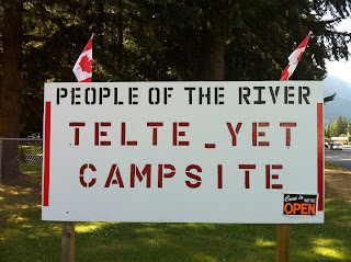
Our first planned stop was the Tetle Yet Campground in Hope, British Columbia.  Prior to leaving, I looked up First Nation Campgrounds.  I read that a number of tribes are opening their lands up to tourists but Tetle Yet was the only one I found on the web.


We arrived in early evening which gave us some time to set up camp and explore the District of Hope.  I went into register at the office and asked about an indian price.  The young man asked for my card, wrote down my band number and gave me a discount.  YeeHaw!


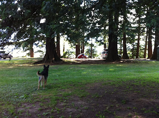
We set up camp along the Fraser River.  There were very few people there and the campground was fenced in so we had an opportunity to play with the dogs with a Chuckit and balls.  The wind was strong and constant.  Not a bad thing.  No bugs!


We headed out to downtown Hope, the "wood carving capital of the world."  We headed South to the Rotary Centennial Park were we saw some examples of the wood carving.


Participatory Art in Downton Hope

We had a great night.  We bought some wood, played some cribbage and watched the campsite fill up with people from all walks of life.  The rush of the wind and water always there.  This was our first night in Canada and we felt at peace and slept.


Tuesday, August 30, 2011

Day Two or How to Travel with an iPhone

We generally started our day with coffee from the coleman stove and a plan for the day.  Phone or 3G service is often times sketchy in the woods, so we rely on our Rand McNally Atlas to check out our timing and miles.  Once we get on the road, we continue to use our atlas but also use the iPhone for other needs.

There are a few apps that are a must for us while we are on the road:

For the dogs we use the Dog Park Finder.  This App lists over 5000 parks across the country.  It has proven invaluable for us as our dogs love to retrieve a ball, but also love to chase a squirrel or other critters and not stop.  The dog parks we look for have fences that limit their proclivity to wander off.  The parks also often have water for the dogs, poop bags, picnic tables to relax at and sometimes other dogs to play with.

The Weather Channel app also is a necessity.  Where is the weather?  Storm brewing?  Where is it headed?  Clear skies?  Hot?  Cold? (not on this trip!)

People who know me, know I am thrifty (cheap).  GasBuddy is app that allows me to find gas near me either by distance or by price.  I have rarely used it by distance.  Locally, our gas prices range from $4.09 to $3.79 today (as listed on my GasBuddy app).  This app helped me find that cheaper gas that I love to fill up on.

There are many other apps that I used:  News, my financial institutions, Google,  YelpUnits as well as the standard Maps app.  Traveling in the 21st century can be as easy as a swipe, some input, result.

We headed to the local dog park, Shastice Dog Park although our maps were a bit off or maybe we were, but we never found the off leash area.  Instead we found an old baseball field with fencing.


A bit of dog play ensued.


Which leads to sleepy dogs for another day of driving.

We proceeded up I-5 passing through Portland, Oregon.  All was going well until I noticed our blanket and sleeping bag flying behind us landing on the highway behind us.  A quick stop to realize that the tube on the car had blown open.  We borrowed the tube from our friend Joan, who misplaced the key.  I thought it would be fine since the car would be with us at all times or at least the dogs would be in it.  The directions for the tube was "3 Clicks."  I remember only hearing two in the morning.  "It'll be OK."  Oops.

We picked up our items and stuffed them back in.  The trip to Walmart was going to happen sooner than planned.  Back to iPhone.  Walmart a few miles ahead.  We purchased a few ratchet straps and a blow up air mattress.  Shoved the mattress in the back and tied down our tube.  Away we go, again.

We decided on stopping at Millersylvnia State Park on Deep Lake just South of Seattle, Washington.  It was a good place to stop as I wanted to enter into Canada the next day refreshed and early.

The campsite was in a wooded area along Deep Lake.  I wanted the dogs to have an opportunity to swim while they joined us on our trek.  We came to found out that dogs were not allowed to go swimming in the swimming area.


Deep Lake Swimming Area

It was getting late, and after setting up our camp, we bought some wood from an overzealous scout and lit our first campfire.


First Fire

BuddyJack was a bit skittish of the fire and Luther was more interested in the dinner that was being prepared by Chef Tom.  Tom bought some Spam for props at concessions at the PAC when Spamalot was playing there.  We've had them for over six months and were packed in our food bag.


Making Dinner

Tom fried that Spam up and mixed it up with some rice.  Spambalaya!  I must admit, I had Spam as a kid but never as an adult.  I would not recommend it for anyone on a low sodium diet, but it was tasty.  Clean up time was a favorite time for the dogs.  Leftover Spam was a very special treat for them.

Night came and the stars were out.  The fire was dying out and we were sleepy and anxious for the next day to start.  Canada!  Unknown territories across the continent.  The looming question of whether we could enter the country with some past indiscretions in the states.  Until tomorrow.

Day One to Castle Crags State Park in Northern California

We traveled from SLO County to Vancouver a few years back via Route 1, so we decided to travel via I-5.  My intention was to put some miles on the car the first day and get to Mount Shasta by the end of the day.  There was very little stopping except for the occasional dog breaks and lunch break with our standard fare of PB&J.

Shasta Lake was pretty full, which for CA, is remarkable.  We found our first campsite at Castle Crags State Park.  There were views of Mt. Shasta from a short trail above the camp.  We took these shots of the dogs and of the mountain and crags after setting up our first camp.


Mt. Shasta


Crags


BuddyJack


Luther

The first campsite let us know what worked and what did not.  It also let us know what to expect for the next month.  The first thing that came to mind was the lack of mattress for the tent.  I can sleep anywhere, anyhow.  Tom on the other hand likes his comfort.  I didn't necessarily forget the mattress, but was kinda pinching pennies and hoped that Tom wouldn't notice.  He did, and I promised a trip to Walmart before the next night.

We also learned that there are mosquitoes in the world.  A lot of them!  I had packed some bug spray knowing that they would be around, but since moving to Los Osos, CA where there is very little fresh water, I forgot how prolific they are.

We often have a repacking of the car the first night out and that night proved it again.  The tube on the top of the car had the tent, which meant hat we had to open it up every night.  Poor planning.  It was meant to hold items that were not often needed.  We also had some clothes up, some clothes down.  Socks and underwear were up.  jackets were down.  No sense.

I always forget that we do not change our outer clothes daily when we travel.  It's just so much easier climbing out of the tent and put on the clothes that are at your feet in the tent.  Showers can also be dirty or cold at campsites.

The following morning, we broke camp, rearranged the car, including putting the dogs in the middle and packed items in the rear.  I wanted to have the dogs closer so I could keep an eye on them and they could participate in the view ahead of us, rather than a view of headlights behind them.  They also had the opportunity to look out the window and smell the smells of the open road.


Luther & BuddyJack smelling the sights.


Away we go...

The car was packed with camping supplies, a 30 year old Coleman stove that Tom has had since college, a kitchen box, a food box, a dog & medicine bag and a few bags of clothes filled with clothing for all types of weather.  We put up the gate in the car to keep the dogs in the back and filled up the back seat with more items that we felt were necessary.

Traveling by car for many miles is nothing new for us.  We knew what we needed and we knew what we didn't need.  A few last minute items stuffed in a few knapsacks and it was time to let the dogs in and head out.


BuddyJack & Luther waiting to start our journey.

Two Dudes, Two Dogs, Two Roads

It has been awhile since I last posted and Tom has been threatening to take over this blog.  This is a personal and traveling blog and we have just recently returned from a 10,550 mile road trip which warrants a narrative with pictures and the occasional review.

I, fortunately, work for the State of CA as a Special Events Coordinator and Stage Technician for CalPoly's Performing Arts Center.  The position I hold is what they call an 11/12 position.  In short, I work for 11 months and get paid over 12 months.  August is the slowest time at the theater, thus my month off.

The month of August coincides with my annual PowWow in Restigouche, Quebec as well as Carnival in Provincetown.  I have missed both of these annual events for the past 5 years since moving to California.  The month would give us an opportunity to spend some time with my family and some of our old friends.

Planning the trip takes me awhile.  Research on gas prices, routes, things to see & do and timing require me to scour the internet to get the idea of costs.  This trip was estimated to cost $4000 round trip.  It would involve driving up to British Columbia, taking a right to Quebec following the Trans-Canada Highway, down to Massachusetts and then following Route 6 from Provincetown to Bishop, CA.

I had hoped to blog along the road with AT&T's iPhone.  I contacted them and was told that based on my usage, it would cost roughly $30,000 to utilize my phone in Canada as I had planned.  I was told that there was fast wifi, much faster than the states, available in Canada.  I relied on their comments and decided only to utilize the wifi using my MacBook Pro.

We planned to depart on Tuesday, July 26, 2011.  I also planned on having a packing party the day/night before in order to say goodbye to a few friends, have a cocktail or two and pack the car.  We live next to The Merrimaker, so my thought was to share our packing while drop-ins could have a drink at the bar.  What happened was an impromptu gathering in the field of Morning Glories on the opposite side of the house.  It was a wonderful evening with well wishes, drums and an amazing gift of tube socks filled with rice for neck rests from friends.

To continue the story, press "newer post" below.